


Dynamic Pre-Disaster Forecasting
Systems at IMD
Dynamic Pre-Disaster Forecasting
Systems at IMD

Dr Mrityunjay Mohapatra
Director General, India Meteorological Department (IMD)
Permanent Representative of India with WMO, and
Member of Executive Council, WMO
IISD's invited Distinguished Guest Blog
India experiences various types of natural hazards including cyclones, depressions, heavy rainfall, thunderstorm/Squall/Hailstorm, floods, droughts, earthquake, landslides, heat wave, cold wave and tornadoes etc. Most of these hazards (about 80%) are hydro-meteorological in nature. The risk management of these hazards depends on several factors including (i) hazard & vulnerability analysis, (ii) preparedness & planning, (iii) early warning, (v) prevention and mitigation. The early warning component includes (i) skill in monitoring and prediction, (ii) effective warning products generation and dissemination, (iii) coordination with disaster response units, (iv) capacity building and (iv) public awareness & perception about the credibility of early warning of meteorological hazards issued by India Meteorological Department (IMD). India Meteorological Department (IMD) is the nodal agency for monitoring, analysing, predicting and issuing advisories related to the severe weather developing over Indian region and the north Indian Ocean (NIO) including Bay of Bengal (BoB) and Arabian Sea (AS). In addition to providing advisories to national and state level disaster management agencies, IMD also acts as Regional Specialised Meteorological Centre (RSMC) for issue of advisories to World Meteorological Organisation-Economic and Social Commission for Asia & the Pacific (WMO-ESCAP) Panel member countries in the region including Bangladesh, India, Maldives, Myanmar, Pakistan, Sri Lanka, Sultanate of Oman, Thailand, Yemen, Iran, Saudi Arabia, UAE, Qatar in case of cyclones and storm surges and to south Asian countries in case of heavy rainfall, strong winds and Oceanic waves.
IMD utilises weather analysis and forecasting system in a digital environment to plot and analyse different weather parameters from observational instruments including Automated Weather Stations(AWS), Automated Rain Gauges(ARG), High Wind Speed Recorders(HWSR), GPS based upper air observation system, meteorological buoys & ships, satellites based observations, Doppler Weather Radars and an array of short and medium range global & regional numerical weather prediction (NWP) models (including Global Forecast System (GFS), Hurricane Weather Research & Forecast (HWRF), Statistical Dynamical Model for cyclone genesis & intensity prediction, Multi Model Ensemble, Ensemble Prediction System (EPS), other global & regional models (including European Centre for Medium Range Weather Forecasting (ECMWF), United Kingdom Meteorological Office (UKMO), Japan Meteorological Agency (JMA), National Centers for Environment Prediction (NCEP)) under bilateral arrangement. The decision support system installed in this forecasting system can analyse all synoptic, satellite and NWP model products for genesis, intensity & track monitoring and prediction of severe weather events, prepare forecasts upto five days, depict uncertainty/confidence in forecasts. This system has resulted in reducing time of analysis, improving timeliness of the warning and visibility of warning products leading to reduction in loss of lives as the outcome.
Post Odisha Super Cyclone disaster in 1999, the Government of India undertook National Cyclone Risk Mitigation Project with the help of World Bank in 2005. Early warning was a major component to be taken up by IMD under that project. In 2006, Ministry of Earth Sciences (MoES) came into existence. Projects like modernization of weather forecasting and early warning services of IMD including modernization of the cyclone warning system were initiated during 2007-2008. As part of MoES and IMD's Vision for 2020 adopted in 2010, new technologies & methodologies mainly (i) introduction of modernised observing systems like Doppler weather radar, automated weather stations, automated raingauges, high wind speed recorders (ii) establishment of digitised forecasting platform & public weather services system (iii) adoption of global & regional deterministic and ensemble prediction systems, storm surge and coastal inundation models, (iv) high power computing system to run the models and decision support system for forecasting (v) implementation of all modern means of communication including dissemination through email, SMS, use of social media etc. were included.
Taking the example of modernisation of observational network, the number of Doppler Weather Radars has increased from 4 (2006) to 27, Automatic Weather Stations has increased from 107 in 2006 to 711, Automatic Rain Gauge Stations has increased to 1,350, satellites have increased from 1(Kalpana -1) in 2006 to 3 (INSAT- 3D, 3DR and SCAT SAT) as on 2021. Similarly, there has been significant improvement in forecasting system. The numerical weather prediction (NWP) modelling has improved manifolds in recent years in terms of resolution, amount of data assimilation, lead period of forecast and accuracy. The Ministry of earth Sciences (MoES) now runs 7 global and regional models in house against only 1 regional model 10 years back. The resolution of global models has increased 10 times from 120 km to 12 km and that of regional models 3 times from 27 km to 3 km in these ten years. MoES now runs specific models for different hazards like cyclones, thunderstorm, heavy rainfall, fog etc. The amount of data being assimilated has increased to 100 GB for each cycle of running of models. All these have been possible due to establishment of high power computing system (HPCS) in MoES with the capacity of about 8 PF (8X10¹⁵ floating point operations per second). The lead period of the models has also increased from 48 hours to 10 days forecast in the interval of 3 hours.
All the technological upgradation has led to (i) extension of lead period of warning from 1 day (2008) to 3 days (2014) to 5 days (2018) (ii) extension of cyclone track & intensity forecast from 24 hrs (2008) to 72 hrs (2009) and to 120 hrs (2013), (iii) introduction of extended range forecast (for next two weeks) in 2016 and for cyclogenesis in 2018, (iv) introduction of fishermen warning for entire north Indian Ocean since 2018 (v) district-wise impact based forecast & warning form in 2018, (vi) location specific nowcast (forecast upto 3 hours) against all types of severe weather commenced in 2013 and extended to 1084 cities/towns in 2021 and district level nowcast for all districts since 2018.
There are many sectoral applications of early warning services like agricultural, hydrology, aviation, marine and surface transport, health and power sectors. The application in agricultural sector is worth mentioning. IMD & Ministry of Earth Sciences in collaboration with ICAR, State Agricultural Universities and Other Institutes is rendering the weather forecast based Agromet Advisory Services (AAS) to the farmers at district level through a network of 130 Agro-Met Field Units (AMFUs), known as Gramin Krishi Mausam Service (GKMS). These advisories include weather forecast for next 5 days, preparedness for extreme weather events and advice on agronomic operations. Besides, nowcast (upto 3 hrs) on thunderstorm, hailstorm, strong wind are also disseminated by SMS to farmers through mKisan portal.
In view of the growing population and economic developments, urban flooding is a major threat. Management of urban floods include rainfall monitoring & prediction, early warning system, preparedness, prevention & mitigation approaches. City specific forecast is also being provided for next 7 days and is updated twice a day. Such city forecast for different locations within the city are being provided since 2020. Color coded impact based heavy rainfall warning for urban districts with a validity period of 5 days twice a day has also been introduced. An urban flood early warning system has also been developed for Chennai and Mumbai. It provides impact based flood warning in a granular manner.
During past 10 years, there has been significant improvement in forecast accuracy of various severe weather events including tropical cyclones, heavy rainfall, fog, heat wave, cold wave, thunderstorm etc.
There has been significant improvement in forecasting accuracy with respect to severe weather events including tropical cyclones, heavy rainfall, fog, heat wave, cold wave, thunderstorm. In general, there has been 20 to 40 percent improvement in forecast accuracy of severe weather events in recent five years (2016-2020) as compared to previous five years (2011-15).
Improved warnings with increased accuracy and high lead period against hazards like cyclones, heavy rainfall and heat wave has helped the disaster managers and general public to minimize loss of lives and property. Especially, the deaths due to cyclones have been limited to less than 100 in recent years.
Though there have been significant improvement in monitoring, forecasting and warning system of these hazards in recent years due to modernization programme of Ministry of Earth Sciences (MoES)/IMD and policy frame work of Govt. of India, there is still scope for improvement at state and district level in terms of (i) improving the mesoscale hazard (like thunder storm, hail storm, squall etc.) detection and monitoring, (ii) improving the spatial and temporal scale of forecasts upto village level through technological upgradation, (iii) sectoral applications of early warning, (iv) warning communication to last mile and disaster managers through state of art technology like common alert protocol and (v) developing synergized standard operation procedure among the early warning agencies & user agencies. All these aspects are being addressed by IMD and MoES in collaboration with state and central agencies.
________________________________________
Dr Mrityunjay Mohapatra is Director General, India Meteorological Department (IMD), New Delhi and Permanent Representative of India with World Meteorological Organization (WMO), and also the Member of Executive Council, WMO at Geneva, Switzerland.
This is an IISD's Invited Guest Blog, under Distinguished Personality Category.

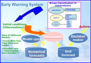
Components of Early Warning System
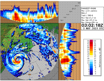
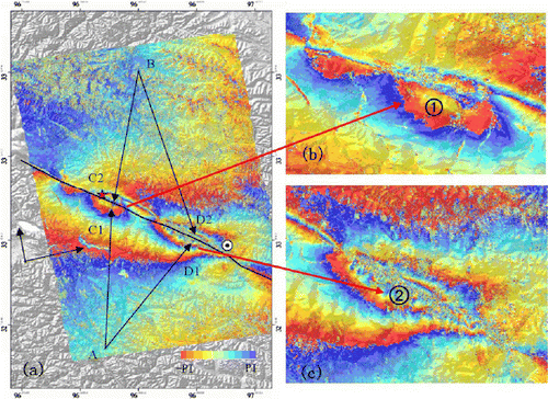
Typical Radar imagery from DWR Paradeep for ESCS FANI over Bay of Bengal near landfall time.
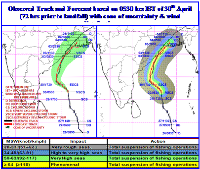
Observed and forecast track based on 0530 hrs IST of 30th April (72 hrs prior to landfall) of ESCS FANI indicating accuracy in landfall predictions near Puri (Odisha)

Understanding global natural disasters and the role of earth observation